Airport Driven Growth in Central Quintana Roo
The Felipe Carrillo Puerto International Airport, inaugurated on December 1, 2023, is reshaping the development landscape of Central Quintana Roo. The airport served over 1,074,000 travelers in its first year, quickly establishing itself as a strategic multimodal gateway for tourism, commerce, and logistics.
While passenger traffic saw a slower pace in early 2025, the broader trend remains upward. Based on current growth trajectories, the airport is expected to handle more than 2.5 million passengers by late 2027.
The facility offers direct connectivity to major destinations across Canada, the United States, and Europe, including routes to Toronto, Dallas, Frankfurt, Madrid, and London. This expanded network is positioning Central Quintana Roo as an increasingly important node in international tourism and trade.
Currently, all vehicular traffic to and from the airport flows through a single corridor—Highway 307 northbound to Tulum—creating a short-term bottleneck that concentrates movement and consumption along a narrow spine. Yet, this same constraint is setting the stage for a highly leveraged breakout in adjacent zones such as Postal Code 77130, where access improvements are expected to unlock rapid distribution and development potential.
Rising traffic volumes are expanding the corridor’s highway capture potential, with more travelers flowing through secondary roads and regional intersections. This shift is driving a measurable uptick in retail consumption, particularly in convenience and service-based sectors positioned along the access routes to the airport.
As demand for access and services increases, investor timing has become critical. Strategic land absorption is already underway, with early movers securing parcels near key junctions and tourism nodes. Delays in infrastructure permitting or capital deployment could mean missing the window for favorable positioning in what is becoming a progressively more competitive landscape.
Rail, Road, and Air: A New Infrastructure Core
The airport is fully integrated with the Tren Maya via an on-site station offering direct rail access to Cancún, Tulum Centro, and other key southern markets. Located just 2 minutes from the terminal and with express trains to Parque Jaguar and the Mayan Ruins, this facility aligns air and rail infrastructure to create seamless movement for passengers and cargo across the Yucatán Peninsula.
Complementing the air/rail port, the 16km primary access corridor to Federal Highway 307, at km 201, will serve as the backbone of a security, logistics and commercial support zone.
Currently, all vehicular access to the airport relies on Federal Highway 307 at KM 201, creating a highly concentrated traffic spine between the terminal and Tulum. This short-term bottleneck, while commercially valuable, is prompting a broader connectivity initiative that includes:
- Expansion of Federal Highway 307 (4 lane) to improve north–south throughput and reduce friction for logistics and tourism mobility.
- A northeast bypass linking the airport to the Tulum–Cobá corridor, aimed at diverting regional traffic from the saturated 307, now "av. tulum".
- New commercial access on the north side of Airport Ave, connecting to Highway 307 at KM 212+300, will enhance the logistical flow and open new capex demand.
- (rumor mill) private expressway access toward the hotel zone "Tulum Beach" and emerging districts of Nuevo Tulum, that will integrate medium-capacity tourism and hospitality.
- Urban basic services and mobility enhancements in Muyil and José María Pino Suárez to support mobility, quality of life and labor capacity.
This growth is expected to expand the airport’s economic catchment zone dramatically, redistribute land absorption pressures, and accelerate regional land value convergence. For investors and operators, access timing remains the most strategic variable.
Beginnings of Commercial Activity
While development intensity remains modest, the first tangible signs of commercial activation are now visible. The 16-kilometer corridor linking the airport to Federal Highway 307 is emerging as a strategic axis for service infrastructure, attracting national brand activity. Quietly but decisively, definitive groundwork for a larger commercial ecosystem has been laid.
Private sector initiatives along the Muyil - Tulum corridor—and the greater Laguna Nopalitos area—suggest increasing confidence in the area’s medium-term potential. With mixed-use concepts and hospitality nodes beginning to take form, the region is now showing initial signs of physical investment.
- Fuel services: A PEMEX station is operational along the corridor, reinforcing both logistics feasibility and highway integration.
- Rental cars: Avis, Hertz, and Europcar are actively servicing travelers through on-site and nearby agencies.
- Retail development: Early-phase support facilities and convenience-based commerce are appearing throughout key junctions.
- Mixed Use and Residential to the east of 307: Awen, Consciente, Soy Tulum (etapa 1), "Pino Norte" (Road Network), Nara, Boann.
Institutional Security & Investment
Speculation aside, the airport and corridor have been developed atop a deep foundation of institutional infrastructure. Strategic military and security investment—often overlooked in conventional development narratives—is playing a decisive role in shaping this zone as a long-term anchor for federal operations and investment protection.
- Air Base No. 20: Inaugurated February 2025, the new base consolidates regional defense operations and ensures permanent airspace monitoring, search and rescue capability, and national sovereignty over critical aviation infrastructure.
- National Guard Detachment: Operational since April 2025, this facility is tasked with active security patrols across the terminal, Tren Maya station, and highway corridor, delivering constant federal presence across the entire intermodal node.
- Strategic logistics perimeter: Internal road systems and base infrastructure have been expanded to support contingency response, logistical mobility, and coordination with municipal civil protection units.
For long-view investors, the result is a corridor not only defined by growth potential—but by embedded stability. With federal assets in place, operational continuity and rule-of-law protection are structurally hardwired into the region's development trajectory.
Key Milestones
Parcela 919 — 4.5 ha (11 ac) for sale
- ✔ 100 m highway MX-307 frontage
- ✔ 44,700 m² global surface| 25,700 m² net buildable + 19,000 m² conservation buffer
- ✔ Cash price $17.2 M MXN | Owner-finance 30 % down, 6 % p.a.
- ✔ 6 m nconservation easement along northern perimeter
- ✔ Warranty Deed, Public Registry — zero ejido exposure
CP 77130: Population Momentum in the Airport Microregion
This corridor lies within zipcode 77130, encompassing villages like Muyil (Chunyaxché), José María Pino Suárez, Chumpón, Chun On, Chun Yah, and Yokdzonot. As of the 2020 census, the local civilian population was approximately 1,925 residents.
Military personnel stationed at the airport and Air Base No. 20 are not included in these figures. The municipality’s own development program identifies the presence of a “floating population” placing pressure on infrastructure and services even before formal urbanization begins.
According to the Programa Municipal de Desarrollo Urbano (PMDU) de Felipe Carrillo Puerto 2024, two long-range population growth scenarios are outlined:
- Scenario 1 – Trend-based growth: From 83,990 residents in 2020 to 116,613 by 2050.
- Scenario 2 – Tren Maya & Airport-driven growth: Up to 204,127 residents by 2050.
This second scenario reflects current realities more closely, accounting for the Tren Maya, airport operations, institutional infrastructure, and the urban-commercial corridor now taking shape. Under this model, the 77130 zone is expected to absorb a significant portion of the projected 120,000+ new residents over the next 25 years.
Source: Programa Municipal de Desarrollo Urbano (PMDU) de Felipe Carrillo Puerto 2024, p. 68
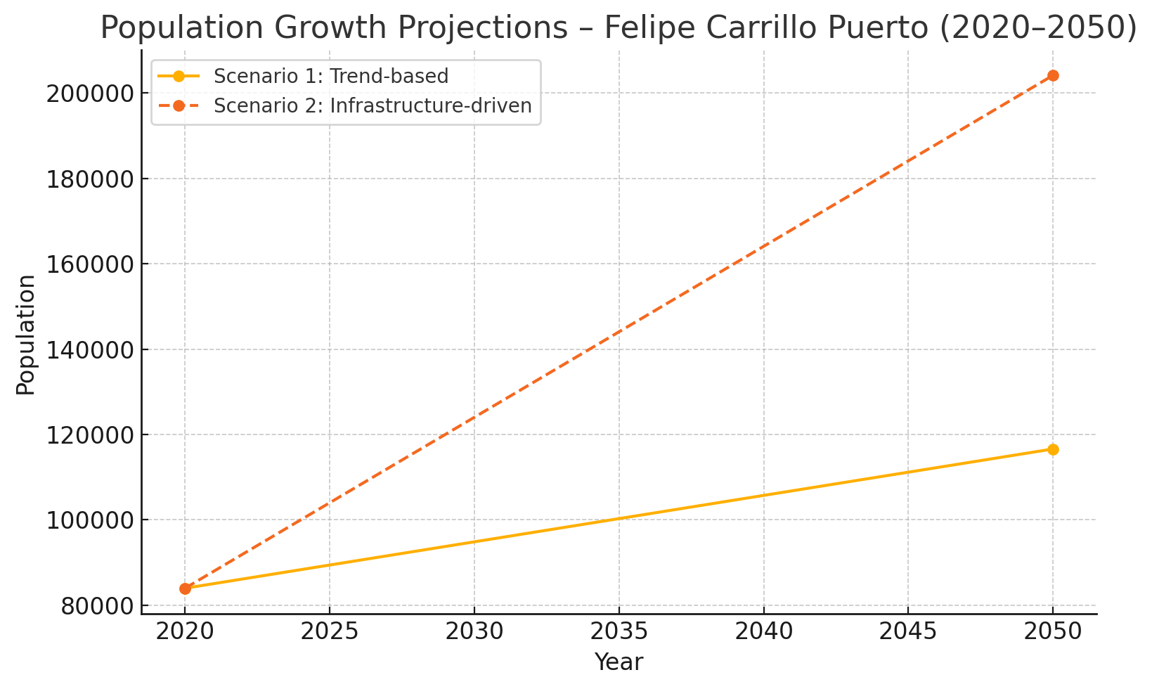
Population growth projection scenarios based on PMDU 2024 data (p. 68)
Microregional Forecast: Airport-Corridor Population Growth (2025-2028)
The Felipe Carrillo Puerto PMDU identifies the corridor between the Tulum International Airport and the Tren Maya station as one of the region's most dynamic growth nodes. Unlike general municipal forecasts that distribute population evenly, the plan specifically cites "atypical increases" in these areas, driven by transportation infrastructure, labor migration, and residential tourism development.
To create a microregional forecast based on these conditions, we applied a best-guess model using passenger growth, national migration patterns, and documented urban development behavior around transit nodes. If the airport reaches 2.5 million passengers by late 2027 (accumulated) —a modest expectation—the surrounding corridor is likely to experience compounded settlement pressure.
Using conservative estimates, we project that 10% of passengers will become repeat or seasonal visitors, 10% of those may transition to permanent residency, and 35% of that group may settle in zipcode 77130, yielding approximately 8,750 new residents over the next 30 months. This population influx would effectively quadruple the current local population, transforming small villages like Pino Suárez and Muyil into key rural hubs.
The PMDU anticipates asymmetrical growth these key infrastructure projects. To reflect this, we’ve developed a custom model based on forecasted air traffic and conservative national migration behavior.
If the airport reaches 2.5 million passengers (accumulated) by late 2027, even a modest conversion rate suggests over 8,000 new permanent residents in the surrounding microregion—quadrupling the current population in less than 3 years.
| Metric | Estimate |
|---|---|
| Forecasted Airport Traffic (2025-2027) | 2,500,000 passengers |
| Seasonal Visitors (10%) | 250,000 individuals |
| Permanent Residents (10% of seasonal) | 25,000 individuals |
| Settled in Corridor (35%) | ~8,750 individuals |
Millions will visit. Thousands will stay.

A data-driven forecast based on traffic through the Tulum International Airport suggests that 8,750 permanent residents may settle in 77130 over the next 30 months.
Strategic Outlook
As northern Quintana Roo reaches structural saturation, institutional focus is shifting south—toward the Highway 307 corridor anchoring Felipe Carrillo Puerto International Airport. This is not a geographic redirection, but a reallocation of strategic attention toward a zone characterized by publicly managed operational infrastructure, and systemic alignment.
The Airport corridor is no longer a projection. It demonstrates how nation-backed infrastructure and regulatory presence can intersect with commercial intent and ecological considerations to form a resilient growth model. Intermodal access, layered security, and pre-positioned logistics combine to form a terrain of staged deployment.
For long-cycle capital, this represents an inflection point where the fundamentals are priced below their trajectory. Land, services, and access are converging into an investable framework still early enough to permit asymmetric positioning. The risk is not volatility—rather shorting the area's growth.
This corridor is not a response to market saturation elsewhere; it is a calibrated emergence. It marks a realignment of Mexico’s investment gravity toward central areas of the state.
Parcela 919 is already sitting on a tsunami of demand—before you even factor in growth. Thanks to massive public spending (think: new international airport, Tren Maya, and a state-funded bypass), this 4.5-hectare, fully titled polygon captures a year-round mix of tourists, commuters, and local commerce right now. Its 100 meters of MX-307 frontage, (starting at km211+520) makes it a recession-resistant cash machine: convenience retail, logistics hubs, fast-casual food—you name it, the traffic is already there to pay the rent.
Here’s the kicker: whatever headline growth shows up tomorrow—more hotels, new routes, population inflows—just layers extra upside on top of today’s rock-solid cash flow opportunity. In other words, you don’t need blue-sky projections to pencil this deal; the government has pre-funded the footfall. Future expansion simply compounds land value, cycle after cycle.
The for sale sign is out.
This is one of those rare “sleep-at-night” land plays that’s diversified, downturn-proof, and primed for compounding appreciation.
Looking for Grounded Growth?
Parcela 919 sits in the heart of Central Quintana Roo’s new mobility node.